
The Massive Locks Bypassing Niagara Falls
47sShows an incredible 8-lock canal system that allows ships to bypass the falls, a hidden engineering marvel.
▶ Play Clip"Delivers on 'hidden engineering' with deep dives into canals, tunnels, and dams — though the sponsor segment slightly dilutes the focus."
Niagara Falls is a spectacular natural wonder with a 50-meter drop and immense flow, but it also presents significant engineering challenges. This video explores the hidden infrastructure—canals, hydropower plants, tunnels, and control structures—that manage shipping, power generation, and tourism while preserving the falls.
The Niagara River connects Lake Erie to Lake Ontario, plunging over the Niagara Escarpment to form the falls. The American Falls, Bridal Veil Falls, and Horseshoe Falls are the three main sections.
The falls block direct shipping between Lake Erie and Lake Ontario, requiring a detour. The Welland Canal, opened in 1829, bypasses the falls with eight locks to lift ships over the escarpment.
The canal includes a control lock to manage Lake Erie's fluctuating levels, aqueducts over the Welland River, and a bypass around Welland. It accommodates all types of vessels, from leisure craft to ocean-going ships.
The 50-meter drop provides enormous hydropower potential. The Adams Power Plant (1895) was the first large-scale AC plant, outputting 40 MW. Today, combined capacity exceeds 4,000 MW from 39 turbines.
Water is diverted into five massive tunnels before reaching the falls, with 50-75% of the river's flow used for power. Giant doors allow tunnel closure for maintenance.
An upstream dam adjusts water flow between tourism and power. During peak tourist season, more water goes over the falls; at night and winter, more is diverted for hydropower.
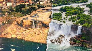
Diversion has slowed the falls' natural erosion from 3 feet per year to about 1 foot per year. In 1969, a cofferdam temporarily dried the American Falls for inspection.
Niagara Falls exemplifies the balance between natural wonder and human infrastructure—canals, tunnels, dams, and power plants all work together to serve shipping, energy, and tourism.
Niagara Falls is a microcosm of civil engineering, where natural beauty coexists with massive infrastructure for shipping, hydropower, and water control. The diversion of water not only generates electricity but also slows erosion, preserving the falls for future generations.
What is the vertical drop of Niagara Falls?
50 meters (164 feet).
00:01
In what year did the Welland Canal open?
1829.
03:12
How many locks does the Welland Canal have?
8.
03:29
What was the output of the Adams Power Plant in 1895?
40 megawatts.
06:20
What percentage of the Niagara River flow is diverted for hydropower?
50-75%.
08:06
In what year was the American Falls dried for inspection?
1969.
12:00
How fast was Niagara Falls eroding before water diversion?
3 feet per year.
10:56
How fast does Niagara Falls erode now after diversion?
1 foot per year.
11:28
Who built the temporary cofferdam in 1969?
The US Army Corps of Engineers.
12:12
What is the combined capacity of the hydropower plants at Niagara Falls?
Over 4000 megawatts from 39 turbines.
07:49
Geographic Overview
Sets the stage for understanding the infrastructure challenges posed by the falls.
01:21Falls as Shipping Bottleneck
Explains why the Welland Canal was necessary for Great Lakes commerce.
02:02Birthplace of Large-Scale Electric Power
Highlights the historical significance of Niagara Falls in electrical grid development.
06:07International Control Dam
Illustrates the delicate balance between tourism and power generation.
08:18Diversion Slows Erosion
Shows an unexpected environmental benefit of hydropower infrastructure.
10:561969 Cofferdam Inspection
Demonstrates the engineering effort to preserve the falls, even when the decision was to do nothing.
12:00[00:01] Niagara Falls is one of the most spectacular waterfalls in the world. With a vertical drop of more than 50 meters or 164 feet and a flow rate that often exceeds 2800
[00:13] cubic meters per second or 100,000 cubic feet per second, it’s one of North America’s crown jewels. Roughly ten million people visit the falls every year just to catch a glimpse of the curtains of
[00:26] water pouring over the edge and the constant clouds of mist at the bottom. But Niagara Falls isn’t just a tourist attraction. The special geology and hydrology of this region, situated
[00:39] between Lake Erie and Lake Ontario, have resulted in some fascinating feats of infrastructure, from shipping to electricity to water control. It’s basically a microcosm of all the things
[00:51] I love. The falls themselves have required quite a bit of engineering over the years, and they’ve even been shut off for maintenance. Let’s take a little tour of the Niagara Peninsula aren’t usually listed in a guidebook. I’m Grady, and this is Practical Engineering.
[01:21] This is a map of the isthmus. We’ve got Lake Erie to the south, Lake Ontario to the north, Buffalo and western New York to the East, and Ontario, Canada,
[01:33] to the west. The Niagara River runs northward, connecting the two great lakes. And right in the middle, it plunges off the Niagara Escarpment, creating the famous falls. On the US side,
[01:45] there are the American Falls and the smaller Bridal Veil Falls. And on the Canadian side is the Horseshoe Falls where a majority of the river flows. It’s pretty impressive to see in person, but it’s actually not entirely a benefit. Because these falls pose a major problem for shipping.
[02:02] The Great Lakes form the largest inland freshwater transportation system in the world. Since the 19th century, they’ve served as the backbone for moving iron ore, coal, grain, and manufactured
[02:14] goods between the American heartland and the Atlantic Ocean. Ore from Minnesota and grain from the Midwest can travel by ship all the way to steel mills or export terminals on the East Coast.
[02:26] Barges and freighters are efficient at moving bulk cargo in a way rail and trucks can’t match. For a time, the Niagara Escarpment was a natural bottleneck between Lake Erie and Lake Ontario,
[02:38] preventing goods from moving directly between the upper lakes and the Atlantic. Freight had to be offloaded and portaged around the falls before it could continue its journey. The Erie Canal solved the problem somewhat, starting in 1825, bypassing Lake Ontario. But it could only
[02:55] accommodate smaller vessels, and even before the Canal opened, another solution was being planned. The Welland Canal runs through the peninsula west of the Niagara River, connecting two massive areas by shipping traffic for the first time in 1829. The canal fueled the
[03:12] early growth of cities along the Great Lakes and St. Lawrence River - including Cleveland, Detroit, Milwaukee, Chicago, Toronto, Montreal, and Quebec City - and it’s been rebuilt and moved several times over its life. The Welland Canal is really a titanic engineering achievement and,
[03:29] were it not positioned next to one of the natural wonders of the world, it would probably be famous in its own right. Because of the huge difference in elevation between the two lakes created by the escarpment, eight separate locks are required to allow ships to traverse between them. And
[03:44] all different kinds do - from personal leisure craft to the lakers that stay in fresh water to the salties that travel between the lakes and the ocean through the St. Lawrence Seaway. Starting on the upstream, Lake Erie side of the canal, the first lock isn’t really for lifting
[04:00] or lowering ships so much as for control. The level of Lake Erie actually fluctuates throughout the year, and there are longer-term trends as well. Wind storms also raise the level locally similar to the way storm surge works during hurricanes. The control lock does just that:
[04:16] it controls the level in the downstream canal. It prevents excess water from rushing down the canal when the lake is high, kind of like an airlock on a spaceship keeps air from rushing out when astronauts step outside for a spacewalk.
[04:30] Downstream of the control lock, the canal splits in two. The original pathway of the canal flows through the eponymous town of Welland, while the larger and newer section of canal, the Welland Bypass… well, it bypasses Welland to the east. If you look carefully,
[04:45] you’ll also notice a small river, the Welland River, which passes underneath both the original and bypass canals. On the way downstream from Lake Erie to Lake Ontario, shipping traffic passes over aqueducts that pass over a natural river. A hydrological wonderland!
[05:02] Continuing downstream from the aqueducts, the remaining seven locks are lift locks, more like what you think of when you imagine a lock. Notice how they’re clustered tightly around the terrain and not distributed evenly along the length of the canal. That’s the Niagara
[05:16] escarpment, the same geological feature that the water cascades down at the falls. This is the elevation diagram of the entire Great Lakes and St. Lawrence Seaway system from Lake Superior to the Atlantic Ocean, and you can see that this drop is the biggest one of the whole
[05:33] thing. And that’s pretty important for another part of the infrastructure on the peninsula. The power available from a moving fluid is directly proportional to the flow rate multiplied by the height of the drop. In most hydropower applications, that height is created
[05:49] artificially by a dam. There aren’t that many places in the world where you have both a large volume of flowing water and a significant natural drop in elevation. But that combination made Niagara Falls the birthplace of large-scale electric power in North America.
[06:07] opened the Edward Dean Adams Power Plant, built with Westinghouse AC generators based on the ideas and patents of Nikola Tesla. The plant served as the basis for the modern
[06:20] electrical grids we have today, and many of the fundamental concepts are basically unchanged. But the power infrastructure at Niagara Falls definitely has changed. Where the Adams Power Plant put out about 40 megawatts of power in 1895, now the combined capacity
[06:37] from the region is in the neighborhood of 5 gigawatts. But in both cases, it wasn’t as simple as putting a turbine at the base of the falls. While it might be technically possible to generate power by placing a water wheel directly in the stream
[06:50] of a waterfall like a kid’s bath toy, it’s not the most efficient way (plus it would take away from the beauty). The water used to power the hydroelectric plants on both the US and Canadian sides of the Niagara River is water that never actually flows over the falls. Instead,
[07:06] it’s diverted into five massive tunnels - two on the US side and three on the Canadian side. Like most tunnels, you can’t really see the extent of the hydro tunnels at Niagara Falls. There are a few conspicuous clues though, like these gigantic buildings.
[07:22] These interesting protrusions from the landscape house enormous steel doors, nearly 60 feet tall, that can drop down into the tunnels and close off the flow for inspections and maintenance.
[07:34] Both the Ontario and New York sides of the river feature similar structures. From the tunnels, water flows into major hydropower plants on both sides of the border: the twin Adam Beck stations on the Canadian side and Robert Moses station on the US side.
[07:49] Then it’s released into the the lower part of the river below the falls. When you add them up, that’s 39 turbines with a combined capacity of more than 4000 megawatts. It’s a tremendous amount of power generation in one place. But actually, that’s not all of it.
[08:06] These tunnels divert 50-75% of the flow of the Niagara River. That wide range in percentage of diversion isn’t because we don’t know how much is diverted, but because we actually control
[08:18] how much water is diverted, depending on the tourist requirements agreed upon in a treaty by both nations. During the day in peak tourist season, more water is allowed to flow over the falls to ensure the grandeur of the falls is on full display for the huge crowds of tourists that
[08:34] visit every year. At night and during the winter, more of the flow is diverted to generate power. That’s all managed by this structure upstream of the falls: the international control dam.
[08:46] across the river. But it doesn’t need to. This structure’s not meant to create a reservoir; it just subtly adjusts the level in the river to control how much water flows over the falls
[09:00] versus into the hydropower intakes. The US side of the Niagara River is pretty shallow, so that side acts kind of like an uncontrolled spillway. Then, the gates on the Canadian side can be adjusted to balance the competing demands on water between tourism and power.
[09:16] But there’s one big problem with those competing needs: they both have the same timing. We want thunderous cascades of water over the falls during the day when tourists are visiting, but daytime is also when the demand for electricity is highest. It’s like if solar
[09:31] panels only worked at night. To accommodate this, both the US and Canada have pumped storage plants. At night, excess electricity is used to pump diverted water into reservoirs,
[09:44] essentially storing both the power and the extra water that’s available during off-peak hours. Then, during the day, the water is released back into the forebay of the power plants. You get a little extra power from that drop out of the reservoir into the forebays, so both sides have
[10:00] small hydropower facilities to capture that. But more importantly, you get a lot more water during the day than would otherwise be available to run through the big plants, making more power when it’s needed most. And there’s just something funny to me that the infrastructure is duplicated
[10:17] on both sides of the river, like neither country was willing to be one-upped by the other. All of this diversion noticeably reduces the flow of water over the falls. Even when they are at ‘full blast’ during the day in the tourist season,
[10:30] only 50% of the flow of the Niagara River makes it over the falls. You can imagine how powerful the falls would be if 100% of the flow were to cascade over. It might seem like this diversion
[10:42] detracts from the majesty of the falls, but in another sense, it actually preserves it. All waterfalls undergo some degree of erosion as the water and sediment suspended in it scours away the rocks and soil underneath. Without any diversion,
[10:56] Niagara Falls would be receding towards Lake Erie at a rate of about 3 feet every year. At the end of the last ice age, the falls were right at the edge of the Niagara Escarpment, but thousands of years of erosion have caused them to work their way upstream. You can actually see
[11:12] how far it’s already progressed by looking at this elevation map. Over the last 12,000 years or so, the falls have migrated by erosion to their current location. By diverting a significant portion of the flow, the power plants have actually slowed the rate of
[11:28] erosion to approximately one foot per year, which will help preserve the falls for a longer period. While flow on the falls is downregulated by diversion for hydropower, the falls are never ‘turned off’...except for the one time in the 1960s. The smaller American Falls (and nearby
[11:44] Bridal Veil Falls) have a pile of loose rocks and boulders, called talus, at their base. This pile of rocky debris actually extends a good fraction of the way up the falls, and officials worried that the falls might ultimately transition into a series of rapids cascading down
[12:00] the slope of talus rather than remaining a majestic waterfall. So, in 1969, the Army Corps of Engineers built a temporary cofferdam between the New York shoreline and Goat Island,
[12:12] diverting the water over the Canadian Horseshoe Falls and leaving the American Falls dry(ish)! After the engineers got a chance to inspect the situation, they determined that the best course of action was just to leave the majority of the talus in place, since it seemed to be stabilizing
[12:29] the cliff face. Sometimes, doing mostly nothing is a decision you make as an engineer, even if you have to do a monumental amount of work to come to that conclusion. So the cofferdam was taken out, and water has flowed continuously over all the falls since then.
[12:45] It really highlights the complexity of Niagara Falls. On the one hand, you have one of the natural wonders of the world, an absolutely enormous set of waterfalls that inspire awe and wonder in the countless travelers who are lucky enough to take in the view. The
[13:01] same thing that makes it impressive for tourists (the big drop) makes it valuable for power and a major challenge for shipping. And out of that comes all kinds of fascinating infrastructure,
[13:13] not only to facilitate the tourism but the other stuff too: a major canal with locks and aqueducts, the international dam control gates, pumped storage reservoirs, epic tunnels, towering gates,
[13:26] massive hydropower plants, and so much more. It’s really a pretty remarkable place for engineering. My wife and I actually visited the falls back in 2018, and even crossed the Rainbow Bridge to the Canadian
[13:39] side for coffee with a view. Like I always do when I’m in unfamiliar territory, I turned on a VPN at the coffee shop before connecting to their WiFi. This is kind of wild, but I’ve been using today’s sponsor, NordVPN for 7 years now. Life’s changed a lot, but my VPN provider hasn’t.
[13:58] Most web traffic is already encrypted these days, but not all of it is. Plus, not all my internet traffic goes through a browser - just about every program I use on my computer, not to mention the apps on my phone, rely on an internet connection, and I don’t always know if they’re using encrypted
[14:14] protocols. In addition, some internet service providers can collect your data and sell it or adjust the speed of your connection based on what you’re doing online. You can also be charged higher prices or blocked entirely from sites and services depending on your location.
[14:30] NordVPN helps me avoid all that. I mostly prefer an internet where the websites don’t know anything about me. And a Nord subscription gives you more than just the VPN. They monitor the web and notify
[14:42] you if your credentials show up in hacks or leaks. The Threat Protection Pro feature warns you about fake webstores and phishing links. And they provide a dedicated IP address. All of it works on all major operating systems for phones, tablets, and computers. And, they have a 30-day
[14:59] money-back guarantee if you decide it’s not a good fit. That makes it easy to give it a try. And what makes it easier is the deal they’re offering right now. Sign up for a two-year plan at the link in the description, and you’ll get four additional months totally free. That’s
[15:14] http://www.nordvpn.com/practicalengineering. Thank you for watching, and let me know what you think!


⚡ Saved you 0h 15m reading this? Transcribe any YouTube video for free — no signup needed.